Six Tornadoes in West Michigan; View Tornado Maps, Radar, More
The National Weather Service has concluded there were six tornadoes in West Michigan on August 20, 2016.
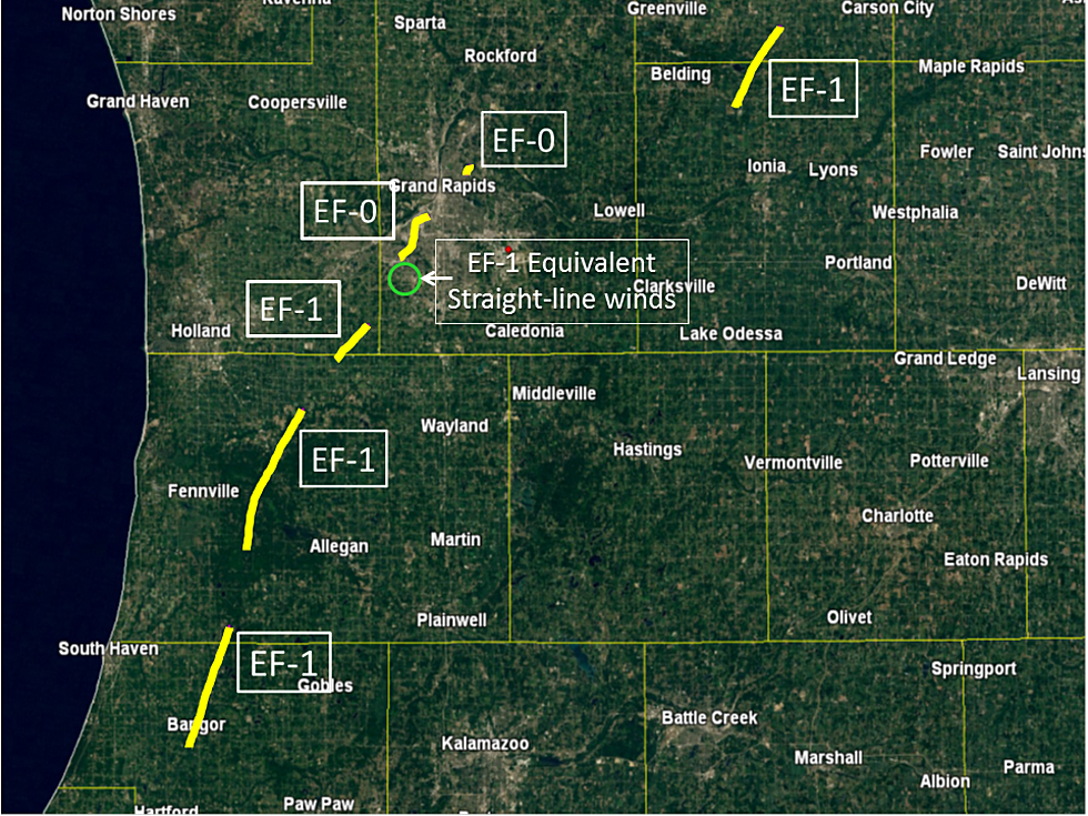
See a map and detailed descriptions of each tornado.
The NWS has raised the total number of tornadoes to six because some gaps have been found in the tornado path in Allegan County. This was originally considered one tornado. Straight-line wind gusts are also newly-noted.
Here is complete analysis of the August 20 tornadoes from the NWS.
Tornado (EF-1) between Bangor and north of Grand Junction in Van Buren and southern Allegan Counties:
- An EF-1 tornado touched down just southwest of Bangor Michigan on Saturday, August 20th and tracked northeast through town. The entire city lost power as well as hundreds of trees. Multiple structures in Bangor were damaged as well. Roof damage was noted on Main Street.
- New Beginning Ministries and the Bangor Police Department sustained damage. The tornado then tracked further northeast, causing significant damage at True Blue Farms along County Road 215 and the Columbia Township Hall in Grand Junction. The tornado tracked into extreme southern Allegan County before lifting about 2.5 miles northeast of Grand Junction on 103rd Ave west of 52nd Street.
- Path width: Approximately 50 to 150 yards
Tornado (EF-1) southeast of Fennville, to east of Hamilton, in Allegan County:
- Additional damage surveys have determined that the EF-1 tornado damage from near Fennville in Allegan County to near Jamestown in Ottawa County was caused by two separate tornadoes rather than one. A gap in the damage path was noted west of Burnips.
- Path width: 50-100 yards
Tornado (EF-1) south of Jamestown in far northern Allegan County and Southeastern Ottawa County:
- Additional damage surveys have determined that the EF-1 tornado damage from near Fennville in Allegan County to near Jamestown in Ottawa County was caused by two separate tornadoes rather than one. A gap in the damage path was noted west of Burnips.
- Path width: 50-100 yards
Two tornadoes (EF-0) in the Grand Rapids metro area, Kent County. EF-1 wind damage also occurred:
- An EF-0 tornado touched down near 44th Street and Ivanrest Ave SW in Grandville Michigan on Saturday August 20th and continued on the ground along a varying path through Grandville and Wyoming before lifting near the intersection of Nagel Avenue SW and Chicago Drive SW.
- Though the tornado remained west of US-131, it did zig zag across a number of major roads/intersections in the Grand Rapids metro area including... ...Ivanrest Avenue SW just north of Rivertown Parkway... ...The intersection of Byron Center Ave SW and 36th Street... ...28th Street SW near Sharon Avenue SW... ...Porter Street SW near Boulevard Drive SW... ...Burlingame Avenue SW just north of Burton Street SW...
- Along the path, hundreds of trees were damaged or knocked over resulting in tens of thousands of power outages. Many homes and a number of vehicles were damaged from fallen trees.
- A couple notable locations the tornado moved through include the Wyoming Middle School football field where a set of football field goal posts were bent by soccer goals, and Battjes Park and Prairie Park where a number of trees were damaged or uprooted.
- In addition to an EF-0 tornado that moved through portions of Grandville and Wyoming on August 20th, National Weather Service damage surveys identified areas of straight line wind damage in Kent County from August 20th storms with estimated winds of around 100mph, equivalent to EF-1 wind damage.
- A small area of wind damage caused by estimated 100 mph winds was found near M6 between Ivanrest Ave SW and Kenowa Avenue SW. South of M6.
- Ironwood Golf Course saw the worst of the damage losing a significant number of large trees. North of M6 just west of Wilson Ave SW along 64th Street a number of very large trees were uprooted causing significant damage to one home. Estimated winds of 65 to 75 mph, equivalent to EF-0 wind damage.
- A long stretch of straight line wind damage occurred from just northeast of the intersection of M6 and Wilson Avenue SW through East Grand Rapids. Notable locations that were impacted by straight line winds include Maple Hill Golf Course and Pinery Park. This damage was mainly to trees with a few fallen trees resulting in damage to homes.
- A brief tornado touched down in Kent County near Perkins Avenue NE between Leonard Street NE and Knapp Street NE. Tree damage and some property damage from fallen trees occurred as the result of this brief tornado.
- Path width: Approximately 25 to 50 yards
Tornado (EF-1) between Orleans and Fenwick in Ionia and Montcalm Counties:
- Tornado damage began just east of the small town of Orleans and moved northeast where it crossed M-44, bringing several large trees down, one of which fell on a house. The tornado then crossed West Long Lake Road where the concrete block wall of a garage was blown out and the wind peeled shingles off the roof of a house. A path of tree damage about a hundred yards wide continued to the northeast and narrowed as it crossed the Montcalm County line. The last damage noted was a few downed trees on East Boyer Road about 3.5 miles southeast of Sheridan.
- Path width: 100 yards
More From 98.7 WFGR